Report Code: 12065 | Available Format: PDF | Pages: 237
GIS in Disaster Management Market Research Report: By Offering (Solutions, Services), Deployment (On-Premises, Cloud), Disaster Type (Natural, Technological), Technology (Remote Sensing, LiDAR, Satellite Imaging), Application (Hazard Mapping, Search and Rescue, Situational Awareness, Damage Assessment, Debris Collection), End User (Aerospace & Defense, Government, Chemicals, Energy & Utilities, Healthcare, Construction, Oil & Gas, Hospitality) - Global Industry Analysis and Growth Forecast to 2030
- Report Code: 12065
- Available Format: PDF
- Pages: 237
- Report Description
- Table of Contents
- Market Segmentation
- Request Free Sample
Geographic Information System (GIS) in Disaster Management Market Overview
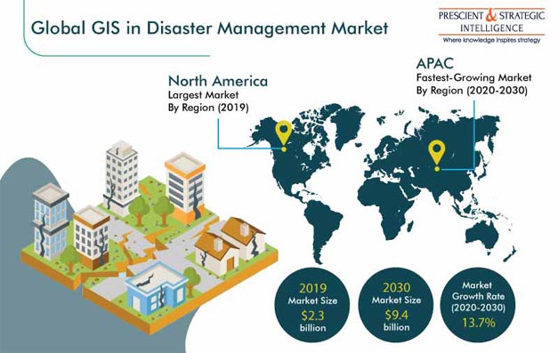
The global GIS in disaster management market size stood at $2.3 billion in 2019, and it is expected to reach $9.4 billion by 2030, exhibiting a CAGR of 13.7% during the forecast period (2020–2030). The major factors supporting the growth of the industry include the surging number of natural disasters, strong focus of government and emergency management organizations on adopting advanced GIS solutions, high need for analyzing geospatial data, and increasing public awareness about reducing the socioeconomic impact of natural disasters.

COVID-19 Impact Analysis
The COVID-19 outbreak has resulted in a high use of geographic information system in disaster management solutions, as enterprises and emergency management agencies are using these solutions for assessing the impact of the global pandemic, thereby resulting in improving growth prospects for the GIS in disaster management market. The geospatial technology is being utilized in interactive maps and field surveys, to gather information related to COVID-19, such as information on its spread. Moreover, the technology also supports the mapping and identification of patients’ addresses/locations, through latitude and longitude data.
Segmentation Analysis
Services Category Is Witnessing Faster Growth in Offering Segment
The services category is expected to demonstrate the faster growth in the GIS in disaster management market during the forecast period. This can be attributed to the growing demand for services such as software integration, maintenance, training, and consulting, for managing the lifecycle of the technology, streamlining processes, and allocating resources, with respect to the use of related software and tools.
Technological Disasters Are Expected To Be Faster Growing Disaster Type Category
The technological category is expected to register the faster growth in the GIS in disaster management market during the forecast period. This can be ascribed to the growing need in industries for effectively monitoring and responding to technological disasters, such as chemical spills, hazardous material leakages, and industrial fires. Moreover, factors such as the growing population, rising urbanization rate, increasing implementation of technology, and surging development of railway and aviation networks are contributing to the increasing chances of technological disasters.
Remote Sensing Is Highest-Revenue-Category in Technology Segment
The GIS in disaster management market is categorized into remote sensing, light detection and ranging (LiDAR), satellite imaging, and others, based on technology. Among these, the remote sensing category accounted for the largest market size in 2019. This is mainly due to the high utilization of the remote sensing technology for the accurate inspection of areas affected by disasters and quick assessment of the impact. The technology helps capture images of the affected areas in a more cost-effective way, as compared to helicopter-based data monitoring, and also provides detailed geospatial coverage and classification.
Hazard Mapping Held Largest Share in Industry
The GIS in disaster management market is categorized into hazard mapping, search and rescue, situational awareness, damage assessment, debris collection, and others, under segmentation by application. Among these, the hazard mapping category held the largest share in the market in 2019. This can be mainly attributed to the need for monitoring disaster-prone areas and generating interactive maps, which enable organizations to access geospatial information and share it with emergency management agencies.
Government Is Largest and Fastest-Growing End User Category
The government category accounted for the largest market size in the GIS in disaster management market, on the basis of end user, and this category is further projected to exhibit the fastest growth in the coming years. This is mainly due to the rapidly increasing focus of government emergency management agencies on the adoption of geographic information system in disaster management solutions, which helps in the collection of real-time geospatial data, in order to mitigate the impact of disasters and plan the allocation of the available resources for search and rescue operations.
Geographical Outlook
North America Is Dominating GIS in Disaster Management Industry
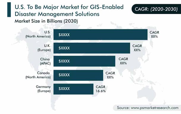
North America dominated the GIS in disaster management market during the historical period (2014–2019). The major factors supporting the industry growth include the strong presence of market players in the region, rising need for integrating next-generation technologies in geospatial solutions, high spending by the government on disaster management, and growing concerns over the increasing losses, due to the damage caused by disasters, such as floods, storms, and cyclones.
Furthermore, a strategic shift toward digital transformation by emergency management organizations is a major factor resulting in the growth of the market in the region. For instance, the American Red Cross utilizes RC View, an enterprise portal based on the GIS technology, which allows for the effective analysis and management of the data provided by Esri Inc., along with data from government agencies, such as the Federal Emergency Management Agency (FEMA) and National Oceanic and Atmospheric Administration (NOAA). The solution supports the organization in providing mapping and analytics capabilities to service delivery teams.
Asia-Pacific (APAC) Region Is Projected To Witness Fastest Growth
Geographically, the fastest growth in the GIS in disaster management market is expected in APAC during the forecast period. The market is primarily driven by the changing climatic conditions and growing incidence of natural disasters, such as floods and cyclones, in densely populated countries, such as China, Japan, India, South Korea, and the Philippines.
Disaster management agencies in the region are increasingly focusing on the adoption of platforms that support them in better understanding and responding to disaster situations. For instance, in January 2020, the National Science and Technology Center for Disaster Reduction, Taiwan developed the Flooding Wargame Simulation platform for training and emergency response purposes. It utilizes ArcGIS, ArcGIS Pro, ArcGIS API, and 3D GIS for analyzing disaster risks and making citizens aware of the situation. The platform also provides 3D visualization of the data related to thematic maps that show flooded areas, emergency shelters, vulnerable residential areas, and network of disaster relief agencies and help assess infrastructure damage.

Trends & Drivers
Rising Preference for GIS-Supported applications
The rising preference for geographic information system in disaster management support applications is the key trend being observed in the market. This is majorly due to the digital transformation initiatives by organizations across the world, which have led to the development of GIS-supported applications. GIS in disaster management facilitates the easy collection of data and provides the user with updated information on vulnerable areas and evacuation needs. For instance, in September 2019, an application, Hurricane Aware, was developed by Esri Inc. for its ArcGIS Living Atlas platform. The application provides information support to the National Hurricane Center and the Joint Typhoon Warning Center, for the prediction of hurricanes (also known as cyclones and typhoons).

Increasing Incidence of Natural Disasters
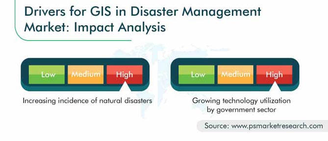
The increasing incidence of natural disasters across the world is one of the strongest drivers propelling the growth of the GIS in disaster management market. The technology is increasingly being used for disaster and emergency management applications, such as for the real-time tracking of early-warning signals, assessment of safe shelter areas, evaluation of emergency supply distribution, and identification of the potential impact on roads, bridges, and buildings.
According to Weather, Climate, and Catastrophe Insight: 2019 Annual Report, the total number of natural disasters in 2019 stood at 409, with economic losses amounting to $232 billion. Hence, owing to the rising incidence of natural disasters and increasing concerns over the large economic losses and danger to life, the adoption of geospatial solutions, particularly those supported by the remote sensing technology, is further projected to increase in the coming years.
Growing Technology Utilization by Government Sector
The surging utilization of the GIS technology by government emergency management organizations is another key driver contributing toward the market growth. This can be mainly ascribed to the rising need for deploying advanced technologies for the effective management of disaster situations, helping communities prepare for disasters, handling search and rescue operations, predicting emergency situations, and estimating the overall damage.
As a result, various emergency management organizations are increasingly focusing on the implementation of geographic information system in disaster management solutions, to facilitate timely decisions during an emergency. For instance, in March 2019, more than 30 tornadoes affected the southeastern U.S. states, including Florida, Alabama, and Georgia. Hence, emergency management organizations, such as NOAA and National Weather Service (NWS), have adopted the GIS technology for the tracking and mapping of the path of the tornadoes, in terms of length, start and end points, wind magnitude, and other factors.
| Report Attribute | Details |
Historical Years |
2014-2019 |
Forecast Years |
2020-2030 |
Base Year (2019) Market Size |
$2.3 Billion |
Forecast Period CAGR |
13.7% |
Report Coverage |
Market Trends, Revenue Estimation and Forecast, Segmentation Analysis, Regional and Country Breakdown, Company Share Analysis, Companies’ Strategic Developments, Product Benchmarking, Company Profiling |
Market Size by Segments |
Offering, Deployment, Disaster Type, Technology, Application, End User, and Region |
Market Size of Geographies |
U.S., Canada, U.K., Germany, France, Italy, Spain, China, Japan, India, Australia, South Korea, U.A.E., Saudi Arabia, Turkey, South Africa, Brazil, Mexico |
Secondary Sources and References (Partial List) |
Association for Geographic Information (AGI), Association of American Geographers (AAG), Association of Healthcare Emergency Preparedness Professionals (AHEPP), Cartography and Geographic Information Society (CaGIS), Geospatial Information and Technology Association (GITA), National Emergency Management Association (NEMA), North American Cartographic Information Society (NACIS), Risk Management Association (RMA), International Cartographic Association (ICA), International Emergency Management Society (IEMS) |
Explore more about this report - Request free sample
Mergers & Acquisitions Are Key Strategic Initiatives Adopted by Players in Industry
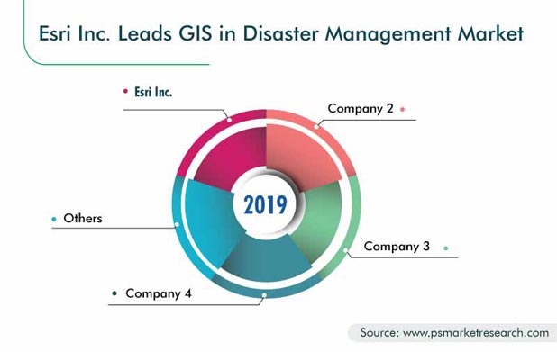
The GIS in disaster management market is consolidated in nature, owing to the presence of players such as Esri Inc., Hexagon AB, Bentley Systems Incorporated, Maxar Technologies Inc., SuperMap Software Co. Ltd., PASCO CORPORATION, and Trimble Inc.
- In June 2020, Bentley Systems Incorporated announced the acquisition of NoteVault Inc., a provider of mobile reporting solutions for construction management, to expand its Synchro digital construction management portfolio with mobile field applications, to track and manage laborers, material, and equipment.
- In February 2019, U.S.-based provider of GIS solutions and services Esri Inc. announced the acquisition of indoo.rs GmbH, a provider of the indoor positioning system (IPS) technology. With this acquisition, the latter’s software became part of Esri’s ArcGIS Indoors. The new mapping product enables interactive indoor mapping of corporate facilities, retail and commercial establishments, airports, hospitals, event venues, universities, and other settings.
- In February 2019, Hexagon AB, a provider of digital solutions, announced the acquisition of Thermopylae Sciences and Technology, a provider of geospatial, mobile, and cloud solutions, primarily for the U.S. government and defense sectors. The company stated that the acquisition would help it deliver the visual location intelligence, necessary for enabling autonomous connected ecosystems.
Some Of The Key Players In The GIS in Disaster Management Market Report Include:
-
Environmental Systems Research Institute (Esri) Inc.
-
Hexagon AB
-
Maxar Technologies Inc.
-
Bentley Systems Incorporated
-
SuperMap Software Co. Ltd.
-
Trimble Inc.
-
PASCO CORPORATION
-
Schneider Electric SE
-
Autodesk Inc.
-
Computer Aided Development Corporation Limited (Cadcorp)
-
Caliper Corporation
-
IQGeo Group plc
-
Satellite Imaging Corporation
GIS in Disaster Management Market Size Breakdown by Segment
The GIS in disaster management market report offers comprehensive market segmentation analysis along with market estimation for the period 2014–2030.
Based on Offering
- Solutions
- Mitigation
- Preparedness
- Response
- Recovery
- Services
- Professional
- Training and consulting
- Integration and maintenance
- Managed
- Professional
Based on Deployment
- On-Premises
- Cloud
Based on Disaster Type
- Natural
- Technological
Based on Technology
- Remote Sensing
- Light Detection and Ranging (LiDAR)
- Satellite Imaging
Based on Application
- Hazard Mapping
- Search and Rescue
- Situational Awareness
- Damage Assessment
- Debris Collection
Based on End User
- Aerospace & Defense
- Government
- Chemicals
- Energy & Utilities
- Healthcare
- Construction
- Oil & Gas
- Hospitality
Georaphical Analysis
- North America
- U.S.
- Canada
- Europe
- Germany
- France
- U.K.
- Italy
- Spain
- Asia-Pacific (APAC)
- Japan
- China
- India
- South Korea
- Australia
- Latin America (LATAM)
- Brazil
- Mexico
- Middle East and Africa (MEA)
- U.A.E.
- Saudi Arabia
- Turkey
- South Africa
Want a report tailored exactly to your business strategy?
Request CustomizationWant an insight-rich discussion with the report author?
Speak to AnalystOur dedication to providing the most-accurate market information has earned us verification by Dun & Bradstreet (D&B). We strive for quality checking of the highest level to enable data-driven decision making for you
Our insights into the minutest levels of the markets, including the latest trends and competitive landscape, give you all the answers you need to take your business to new heights
With 24/7 research support, we ensure that the wheels of your business never stop turning. Don’t let time stand in your way. Get all your queries answered with a simple phone call or email, as and when required
We take a cautious approach to protecting your personal and confidential information. Trust is the strongest bond that connects us and our clients, and trust we build by complying with all international and domestic data protection and privacy laws
